

06 Jul Our US Geography Homeschool Collection: Books, Games & More
This post contains affiliate links. If you purchase through my links, I may earn a small commission at no extra cost to you. I only share things we actually use and love!
So here’s the thing about wanting to do a 50-state homeschool adventure… planned to be made… and I LOVE making plans!
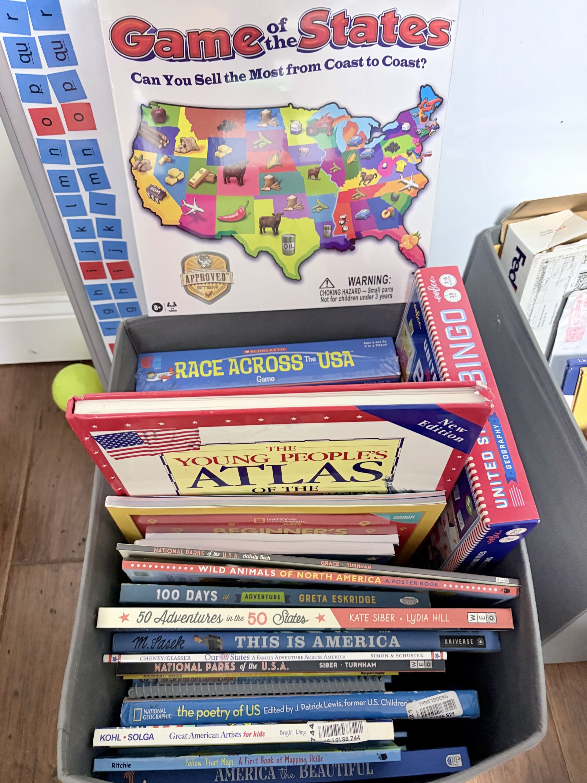
We are in the midst of planning our big 50 states trip (which we’ve decided will actually be smaller, more manageable region-specific trips), visiting every single state as a family while weaving it all into our homeschool curriculum. And while the travel planning is its own beautiful beast, the learning prep has been just as fun. Maybe more fun, because it led to the creation of what I am lovingly calling The Bin.
The Bin is a large storage container in our schoolroom that is absolutely overflowing with US geography books, games, atlases, activity books, and things I told myself were “educational” but may have also just looked really fun. The boys are obsessed. I am obsessed. I have no regrets.
Here’s everything in it, organized for you so you don’t have to dig through a physical bin to find the good stuff.
📚 The Books
Starting with the basics: maps and geography skills
Before you can appreciate the 50 states, you need to understand how maps work. These are the foundational books we’re using to build that spatial thinking.
Me on the Map — A classic picture book that starts with a child’s bedroom and zooms all the way out to the whole world. Perfect first introduction to scale and mapping concepts for younger kids. We still pull this one out.
Follow That Map!: A First Book of Mapping Skills by Scot Ritchie — The perfect entry point for younger kids. It follows a group of friends using different kinds of maps on an adventure, the story format makes the concepts stick in a very concrete way.
Maps and Globes by Harriet Barton — A classic that’s been around forever for good reason. Clear, simple, and genuinely useful for building map literacy from the ground up.
Geography from A to Z: A Picture Glossary by Jack Knowlton — One we pull out constantly as a reference. Landforms, bodies of water, geographic features, all defined with illustrations that make them memorable.
There’s a Map on My Lap! by Tish Rabe — A Dr. Seuss beginner book that covers map basics in true Seuss style. Silly, rhythmic, and surprisingly thorough.
Atlases worth owning
National Geographic Kids Beginner’s U.S. Atlas — This is the one we use the most. Every state has its own spread with maps, facts, photos, and points of interest. It’s designed for kids but genuinely interesting for adults too. Highly recommend having a physical copy because there is something about flipping to a page and seeing a state laid out visually that no screen can really replicate.
The Young People’s Atlas of the United States by James Harrison — A beautiful, slightly more detailed atlas that works well for older elementary kids. The maps are gorgeous and the information goes deeper than most kids’ atlases.
The 50 states deep dives
Our 50 States: A Family Adventure Across America by Lynne Cheney — This one tells the story of a family road trip through all 50 states. It reads like a narrative, which means my boys will actually sit still for it, and sneaks in history, culture, and geography along the way.
50 Adventures in the 50 States by Kate Siber — Exactly what it sounds like. One adventure per state, beautifully illustrated. We use this as inspiration for things to actually DO when we visit each state. It’s also just a genuinely beautiful book to have on the shelf.
Smart About the Fifty States: A Class Report by Jon Buller — Formatted as a kid’s school report, it covers capitals, nicknames, birds, flowers, and fun facts for every state in a totally accessible way.
The United States Activity and Fact Book by Dylanna Press — Activities, maps to color, and state facts all in one. Great for keeping hands busy during our read-alouds or long drives.
This Is America: A National Treasury by Miroslav Sasek — A stunning illustrated book that captures the feel of American landmarks and landscapes. Less curriculum, more coffee table book that we actually read.
Nature + wildlife
Wild Animals of North America — A pretty poster book that doubles as a reference. We’re planning to pull this out as we study states with unique wildlife.
America is Wild!: A State-By-State Encyclopedia of American Wildlife — Each state, its wildlife, and what makes it ecologically unique. This one is going to be so good once we start visiting different regions.
National Parks
We are national park people. There’s a whole section of The Bin dedicated to this.
National Parks of the USA by Kate Siber — A beautifully illustrated guide to 75 national parks. This is one of those books you pick up just to browse and end up not knowing how two hours have passed.
National Parks of the USA: Activity Book by Kate Siber — The companion activity book. Maps to label, facts to fill in, things to draw. My boys have already claimed written their names on their copies.
Art + culture
Great American Artists for Kids by MaryAnn Kohl — Hands-on art projects in the styles of famous American artists. This ties directly into our art curriculum and will be a staple during our states study.
The Poetry of US edited by J. Patrick Lewis — Over 200 poems celebrating the people, places, and passions of the United States. We’re planning to pull poems that correspond to states we’re studying each week.
Eat Your Way Through the USA by Loree Pettit — Each state gets a few recipes. We have big plans to cook and eat our way through this one. It’s going to be messy and delicious.
America the Beautiful by Cholena Rose Dare — A gorgeous picture book version of the classic song with illustrations that span the whole country.
🎨 Art + Drawing
Books dedicated to drawing the USA… this little subcategory snuck up on me and I am not mad about it.
Draw the Natural Wonders of The USA — Rivers, lakes, mountains, deserts, flora, fauna & step-by-step drawing instructions. This one ties perfectly into our science and geography work at the same time.
Draw the USA — Simple, accessible, and the boys can work through it independently. Each page is a new state landmark or icon to draw. Low-prep art that actually teaches geography.
Drawing Around the World: USA — Geography for kids through illustration. Each drawing prompt is tied to something culturally or geographically specific to a region. Sneaky smart.
📖 Reference + Fun Facts
Don’t Know Much About the 50 States — Packed with US and presidential facts in a format that doesn’t feel like reading a textbook. My boys will absolutely quiz each other with this one.
Usborne State Capitals — Exactly what it sounds like and exactly what we needed. Simple, focused, and perfect for drilling the capitals without it feeling like drilling.
Wonders of the USA (Shine-A-Light) — Hold the pages up to light to reveal hidden details beneath each illustration. Landmarks, wildlife, landscapes, the shine-a-light format makes it fun and interactive.
🌿 Nature + Activity
Animals of the USA Activity Book — Activities centered around American wildlife by region. Pairs perfectly with America is Wild! already in The Bin.
Across the USA Activity Book — A broad activity book covering geography, landmarks, and culture across all 50 states. Great grab-and-go for travel days.
Explore! America’s Journeys — Follows different American journeys and expeditions. More narrative than activity book, which means it’s actually a page-turner.
🎲 The Games
Because not all learning happens with a book in your lap. Sometimes it happens while you’re losing to your eight-year-olds at a geography game and trying to save face.
Game of the States — A classic for a reason. Players buy and sell products from state to state, learning what each state is known for producing along the way. Takes a little longer than our other favorite games but the geography and economics learning is genuinely solid.
University Games Scholastic Race Across the USA — Fast-paced and competitive, which means my boys are obsessed. Players race across the country answering geography questions. Great for state capitals and landmarks.
eeBoo USA Geography Bingo — Bingo but make it educational. Each square is a state and you call out clues instead of numbers. Low-prep, high-engagement, and honestly one of those games where you don’t realize how much you’re learning until you find yourself naming state capitals without thinking.
Skillmatics Guess in 10 States of America — A card-based yes/no guessing game that works anywhere, no table required. We bring this to doctors appointments, in the car, to restaurants. Perfect travel game for a family who is always on the go.
YAHTZEE National Parks Travel Edition — Yahtzee but make it a national parks collector’s edition. Each die face features a different park. We grabbed this specifically for road trips because it’s compact and the boys already know how to play. Easy win.
🗺️ Puzzles & More
Because sometimes the best way to learn where Montana is, is to physically pick it up and figure out where it goes… says someone who just recently learned where Montana is…
Mudpuppy National Parks Map Puzzle — A beautifully illustrated map puzzle featuring all the national parks. This one lives in a corner of our homeschool room floor and gets worked on in bits and pieces. Another one where time just seems to fly away.
Melissa & Doug USA Map Jumbo Floor Puzzle — A giant floor puzzle of the US that is perfect for younger kids. Each state is a piece, which means my boys have physically held every state in their hands at this point. That counts as geography.
The Learning Journey Lift & Learn USA Map Puzzle — Each state lifts up to reveal the state capital underneath. Simple concept, genuinely effective. We’ve done this one so many times that certain capitals are just cemented in their brains now.
Learning Resources Magnetic U.S. Map Puzzle — The magnetic version means it works on any metal surface, fridge, whiteboard, cookie sheet. Low-setup, high-repeatability.
Mudpuppy Map of the USA 100-Piece Puzzle — Colorful, illustrated, and sneaky with the learning. Every state is packed with little icons — cows in Texas, Hollywood signs in California, lobsters up in Maine — so the boys are absorbing regional facts without realizing it. This one lives on our schoolroom floor and gets picked at over a few days rather than one sitting.
Learning Wrap-Ups States & Capitals Keys — Self-correcting, no parent-grading required, which is exactly why this one gets pulled out during independent work time. Wrap the string state to capital, flip it over, and the key tells you instantly if you got it right. Low-prep, high-repetition, and somehow the boys don’t mind drilling all 50 capitals this way.
How we’re actually using all of this
Not all at once… that would be chaos even by my standards. Our Beautiful Feet Books US Geography curriculum anchors our Wednesday lessons and we pull from The Bin based on what state or region we’re focused on that week. The games and puzzles happen whenever, game nights, rainy afternoons, Friday enrichment time.
The snail mail project ties everything together. We’ve written letters to the tourism office of all 50 states asking them to send us back maps, brochures, stickers, and anything that represents their state. As the mail comes in, we’ll add those materials to our research journals alongside what we’re learning from these books.
It’s a whole thing. A very messy, very wonderful thing.
Want to see it all in action?
A full book and game haul will be posted on YouTube soon, we walk through every single one. And follow along on Instagram @messylittlehomeschool for updates as we start getting mail back.
Learning is messy. Embrace it! ✨
Bookmark or save this post — it’s a long one and you’ll want to come back to it when you’re ready to build your own US geography collection!
No Comments